

SOMETIMES THE PAST SIMPLY DISAPPEARS
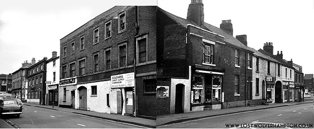
This late 1960’s panorama of the shops and businesses on the north side of Horseley fields, were wiped from the map to make way for the bus station and ring-road.
On the far right of the group is Corn Hill. The main focus of of this feature.
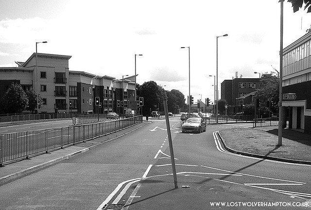
Upper and Lower Horseley Fields once stretched from The Queen’s Building and Pipers Row, (seen above). to St Matthews Church, and the Willenhall Road. and was lined on both sides by Georgian and Victorian shops and houses , it was a real working mans shopping centre.
Branching out on either side were Streets and Courtyards full of small terraced houses, and of course some real characters lived in them.
It was said of Horseley Fields In my grandparents day.
”This half square mile was the most industrious and Commercial quarter, of the whole of South Staffordshire,”
Of which it was then a part, with a population of around 10,000.
But looking at the present day scene today in 2014, We note. When convenience does battle with character, its usually the former that usually wins out.
Over the years I have searched high and low for pictures of Horseley Fields and found them to be very thin on the ground, but with the few I have, and with stories that give life to them, I will try to paint a bigger picture and hopefully offer a greater understanding of how life was there in the past, and how different from today.
TOP to TOE — THEN and NOW
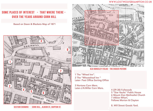
Regarding: The area between Corn Hill, Albion St, and Shipton St.
I have highlighted; what I term to be places that have been of an interest to me, and hopefully some may be of interest to you.
Please refer back to this map when looking at the sites for the following pictures and stories.

When you turn into the twentieth century Horseley Fields the first slip road you pass on your left is Corn Hill. Now only its name and the canal bridge are recognisable from the old hill, once paved in cobbles, I recall as a youth.
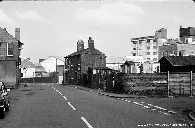
Half way down on the right is Albion Street named after the Albion Wharf and basin over which James Bradshaw built his flour mill, in 1828-29. Bradshaw was described in 1833, as grocer, tallow chandler, miller,baker, corn hop and cheese factor. he was also town Councillor.
About a century ago Miller’s, whose derelict flour mill still stands today on the opposite side of the canal, purchased Albion Mill and since Miller’s closed, Albion Mill as you can see; has now been converted to residential use as part of the redevelopment of the area between Horseley fields and the Birmingham canal.with three or four story blocks of apartments.
On the west side of Corn Hill today is a characterless Car Park adjoining the Ring Road.
But if were rewind the clock back some fifty years we see there is still some life left in the Old Hill then.
On the east side there is a builders merchants in the yard on the corner of Albion Street.and if I remember right the corner grocery shop was in the hands of the same family at that time.
Across the old bridge in the background we see the tall dominant structure of J.N.Miller’s, whilst on the west corner of Corn Hill and its junction with Old Mill Street is “The Wheel Inn”.
Finally the car on the left is parked at the front of The Post Office building which covers the remainder of the ground up to Horseley Fields.

Looking up toward Horseley Fields in the background we see the Wallpaper & Paints shop on the corner of Union Street belonging to J.B. Jones whose premises I recall as a lad, were once occupied by The Household stores.
Again on the east side Corn hill, we see the corner grocery shop, and builders merchants yard .with the old established Hill & Sons iron founders, still active now on in Albion Street
This view of Corn Hill gives us a better picture of the later “ Wheel Inn”, on the junction and also the post office building alongside it.
“The Wheel Inn” built in the early 1800’s was known as the boatee’s Pub, and kept on many occasions by ex boat people.
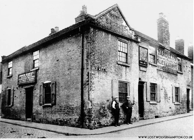
One such family was The Guests, this is just a glimpse of their life and times shared with me, by Sylvia a dear friend.
My mother was born Lily Guest at number 2 Gas Yard, Union Mill Street, Horseley Fields , Wolverhampton on February 16, 1902, the fifth child of John and Mary Guest.
At that time John Guest was a boatman on the canal, For many years he and his family worked the local canals until a bad accident caused him to leave his boat and he took on the License of The Wheel Inn, for Yardleys Brewery, in Old Mill Street, Horseley Fields and he is pictured here standing outside with his oldest son Bill.

The Wheatsheaf was one of at least fourteen Public houses in Horseley Fields in the days between the wars.
The licensee in 1929 was Mr Thacker ,who I recall my uncle Horace Stevens saying possessed a striking handle-bar moustache.
Here today,he has booked two coaches to take his customers and staff on a Sunday morning breakfast trip.
The popular public house building and adjoining shop premise including most of the remainder of the row of terraced houses seen above in Corn Hill came down in the 1950’s to make way for the new, Post Office Sorting Office.
Mr Thacker left at that time to keep the “Holly Bush” Inn, on the corner of Gough Street and Walsall Street.
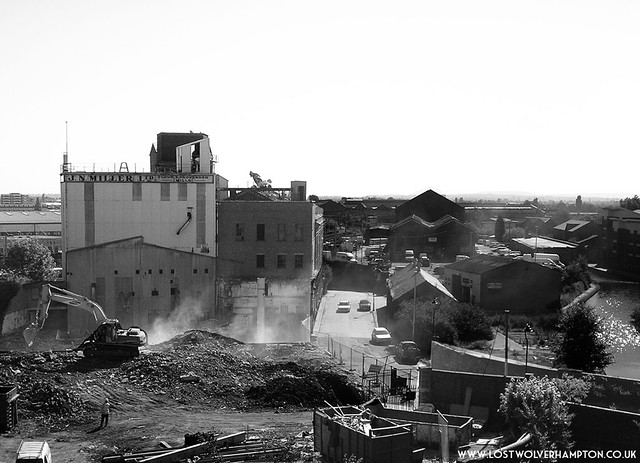
For most of the 1900 century there were three mills trading on this stretch of the canal with a quarter of a mile of each other. The Old steam Mill as it was once known, started alongside the original main line of the canal. After the Old Mill was burned down in 1851 this newer building seen here was designed by William Fairbairn, the well known Manchester -based engineer, using the latest fireproof techniques.
As you can see by this picture taken in 2007 It is a tall structure with an asymmetric plan that reflects the course of the Birmingham canal before its re-routing in the 1850’s.
It was once said; of this building it might be regarded as one of finest examples of large scale industrial buildings of its day, , its interior cast-iron framework is a pioneering example of a nineteenth century fireproof building.
Unfortunately with all the will in the world, I don’t think now after the other disastrous fire which occurred shortly after the above picture was taken any thing or anyone can save it now.
The Shop That never closed.
Numbered No.4 on the map was “Fullwoods”. I remember this sweets and tobacco shop very well it was for many years almost on the corner of Bradshaw Street. It never closed, even on Christmas day you could always go to Fullwoods knowing it would be open. I have still many picture postcard scenes of Wolverhampton purchased from that aladdins cave some 70 years ago.
This story continues, No’s 5 and 6 on the map “The Star Vaults” and Mount Zion Chapel will feature on the next post part nine.
